Large areas of the Great Hungarian Plain (Alföld) and Little Hungarian Plain (Kisalföld) are experiencing severe soil dryness, making crop germination extremely difficult. Although some precipitation is expected early next week alongside a temperature drop, the rainfall will likely be unevenly distributed — according to the agro-meteorological report released Thursday by HungaroMet Zrt.
The analysis notes that while showers and thunderstorms occurred mid-last week — with some places experiencing downpours — dry and sunny weather returned by Sunday. In the region bordered by Szeged, Jászberény, Biharkeresztes, and the national borders, there was no rain at all. Northern Hungary and parts of Transdanubia also received little to no precipitation.
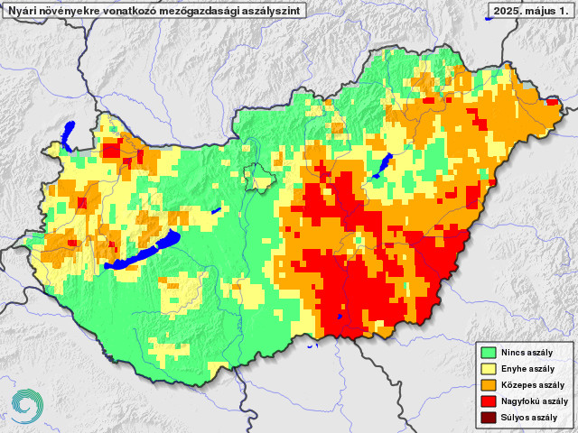
However, in the southwest, central, and northern parts of the country, more than 20 mm of rain fell in many areas, and up to 40-50 mm was recorded in spots hit by downpours. Still, in much of the Great Hungarian Plain, the soil continued to dry out, with the top 20 to 30 cm layer now critically dry, signaling a deepening drought.
Temperature-wise, a cold front brought a nationwide cool-down starting Saturday. Despite plenty of sunshine, Sunday temperatures hovered around 20°C, and weak frosts occurred in northern frost-prone areas by Monday morning. Ground-level frosts were also observed in the low-lying regions of Nyírség and Kiskunság. From Tuesday, temperatures rebounded to around 25°C.
Thanks to favorable soil moisture and temperatures, spring development of autumn-sown crops is progressing well: rapeseed is in bloom, and wheat is entering the stem elongation phase. These crops, with their deeper and more extensive root systems, are still able to access sufficient moisture.
Corn and sunflower germination is supported by suitable temperatures, but surface soil moisture varies significantly. In rain-rich areas over the past two weeks, crops have emerged well, but vast parts of the Great and Little Hungarian Plains remain too dry, making germination extremely difficult.
Most fruit trees have finished blooming, although quince and walnut trees in the north are still in flower, benefiting from the warm weather.
The latest vegetation index, indicating surface “greenness” as of mid-April, shows a significant nationwide increase. The most intense growth is observed in the highlands, where trees have fully greened over the past two weeks. Overall, vegetation is more advanced than the long-term average, signaling an early spring.
Forecasts from Sunday to Tuesday call for significant cloud cover and frequent rain, showers, and thunderstorms. Total rainfall is expected to range from 5 to 30 mm by mid-next week. However, due to the scattered nature of precipitation, distribution will be highly uneven. As a result, the drought affecting summer crops likely won’t end everywhere in the country.
From Sunday, cooler weather will return, with Monday highs only reaching 13–19°C and very chilly nights.
(Debreceni Nap)